VN SkyRadar: Localized astronomical planning for Vietnam photographers
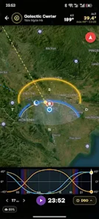
VN SkyRadar, developed by Duy Chris, is a location-aware photography planner for Vietnam that helps you time outdoor shoots precisely. The app pairs real-time astronomical tracking of Sun, Moon, and Milky Way with localized weather forecasts so you can plan around light and conditions. It also calculates sunrise, sunset, and nautical and civil twilight windows together with a moon phase calendar. Landscape, night, and architectural photographers gain a planning tool geared to exact timing and place.

Unlock your creativity with Adobe Stock
Get 10 images or 1 video with a free trial
How SkyRadar supports on-location scouting
SkyRadar centers scouting on maps you can use in the field. The app includes an interactive map for finding and saving optimal shooting locations, letting you mark spots and return to them for repeatable compositions. Use saved points to compare dates and times visually, and orient yourself before you travel; the map removes the need to juggle separate scouting notes and location pins when you plan multiple sessions.
Compatibility and device requirements affect accuracy
The app runs on Android and depends on location hardware for precise results. SkyRadar requires a GPS-capable Android device to perform location-based astronomical calculations, so your timing accuracy depends on the device's positioning. The app is specifically optimized for Vietnamese geography, which means its forecasts and local targets are tuned to regional coastlines, mountains, and latitude ranges rather than a one-size-fits-all global model.
Score checking and consolidated data help you choose windows
The score checking system offers a quick way to rank shoot potential. SkyRadar aggregates weather, light-phase timing, and celestial path information into a single interface that produces a shootability score for specific times. That consolidated view helps you prioritize sessions when weather or moon conditions conflict. The app is generally well-received within its niche, which suggests local photographers value the combined scoring and planning approach.
Choose SkyRadar as a practical gateway for location-focused photographers
If you photograph Vietnam and want a focused planning tool, SkyRadar is a practical gateway that puts regional timing and forecasts at your fingertips; expect a focused, locally oriented workflow rather than a generalized global planner. The developer builds for local photographers, so you get targeted utility and a single-entry planning process that suits shoot-focused workflows more than broad, multi-region scouting needs.